With a tire puncture, I could not cycle out of the "range rover" trail. Azril and Joe were kind enough to walked out with me. I told them that if we can fix the bike, we will go back in again... as I was reluctant to finish the day like that.
However, Azril the Ranger said that normally in a forest, if something like this happens, it could mean that something was telling us not to continue on the trip any more... LOL. Man... I wish he hadn't said that. Pantang!!! Now no one wants to go back to the trail...even if we can fix the puncture... LOL
After walking for about 1.5 km, we came back to the FRIM entrance. I asked the guard if he knew where I could fix a puncture. He told us to turn right pointing to the nearest junction, that there was a motorbike repair shop. We thank him and continued about 100 meters out to the junction.
We searched for quite a bit before finding the repair shop on the main street next to the stalls where we had breakfast in the morning.
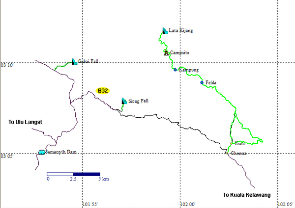
Check out the location on Google Earth and photo here. You will not believe what happened next.
What was supposed to be a simple fix for a puncture turned out to be an education in Astronomy.... LOL.
As it turn out, Mr. Pang of Pang Motor, is the current president of the
Star Finder Astronomical Society. What started out as a simple question of, "Who built that Hubble Telescope model hanging in front of his shop?" turns out to be a lecture in Astronomy... LOL.
Mr. Pang, who owns 3 huge telescopes, was eager to explain to us, the uninitiated, the ins and the outs of star gazing with a telescope and reading the star charts. He would also like to extend an invitation to all who are interested in Astronomy to visit their society website and all are welcomed to join as members.
Between fixing my puncture and tending to his other customers, he explained about the alignment of the planets and how long we have to wait to view some of the stellar phenomenon.
He also had an interest to build and fire water powered rockets, which he and his friends made.
We had an opportunity to try out the telescope.
Mr. Pang fixing the puncture using sanding, patch and glue.
Mr Pang also wrote for an Astronomy Magazine... now tell me you all expected this all along... that we would meet up with an Astronomer while fixing a puncture... HAhahah... Even Joe the Oracle could not have foretold this... LOL...
Finally, the hole in the rubber tube was patched and ready to be inserted back into the tire.
Another look at the telescope showing the hollow inside the telescope body.
I told Mr. Pang that I will be putting all these videos I took on the Wide Geeks's blog. He requested that I took some photo and video of his shop front with a banner promoting the society, of which I gladly obliged... :-)
Azril told us that he will not be joining us when we get back to FRIM for a second hash. Since this was his birthday and the time was just after noon, he had to spend some quality time with the wife and family. Joe and I completely agreed but just before we could leave, Mr, Pang took out some stereoscopic photos to show to us... :-) I could see that Azril was in a hurry, but he politely stayed to view the photos... LOL. The photos were cool!
After Azril had left, Joe and I decided that we would cycle on the tarmac roads, due to the "pantang" of the land rover trails... LOL.
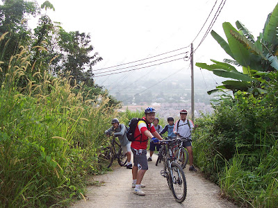
When we headed into FRIM the second time, seems all the cyclist are leaving. Check out that Kancil with the bike racks lah... cool or not??? LOL...
We continued down the road and practically cycled to all the available tarmac roads. We came upon some nice places and FRIM staff quarters.
Check out the location on Google Earth and photo here.More tarmacs... :-)
At this point we climbed a slope and ended up somewhere around the Malaysia Nature Society. There was no more tarmac road ahead. So, I took a chance and cycled to a dirt path next to some camp ground while Joe consulted the GPS.
Joe came up and we decided to risk the "pantang" and go in search of a trail heading to Sungai Buloh... throwing caution to the wind... LOL.
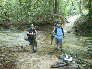
Check out the location on Google Earth and photo here.We rode along the trail among the lush greeneries. The feeling of excitement was back. Riding into the unknown... LOL... We came across a nice waterfall cutting below the trail into the ravine next to us.
Easy ride as we moved along...
It was a easy ride... until we reached this stretch, which was downhill and the trail was filled with crevices made by water gushing down during a heavy rain.
Continuing along the downhill, we came across some caretakers of the forest cutting and trimming the grass and vegetation along the side of the trail.
Further up the trail, we met up with Henry and Jason. I asked them for direction to get an idea of where we were. Also, I told them that we were newbies to MTB and invited them to join us in our next hashing trip if they were interested. We exchanged contacts and I promised to email them the information to the next Wild Geeks hashing adventure. COol!
We continued cycling and were surprised to find a fantastic view of FRIM, some lakes in a park and the surrounding residential area. We cycled for a short while and found the clearing that Henry had told us about. If we take the right, we will be heading towards Sungai Buloh and if we turn left, it was supposed to take us back to the main road, which we passed by that morning on our way to FRIM in my pick-up.
So we turned left and found out that the road lead to some construction site. While Joe consulted his GPS, I rode up the slope to get a better view. When I reached the top, I could see the lakes, and the road seemed to be leading down to them. Unless I rode down, I could not see if the road was actually connected to the lakes were or not.
So I rode back down and told Joe about what I saw. Meanwhile, Joe had consulted the GPS and discovered that we had passed the turning to the lakes earlier. So we doubled back until we found the small tiny trail leading steeply downhill to the lakes!!! And from the lakes to the main road!!! Wah liao eh!
Check out the location on Google Earth and photo here.We made it safely down that steep slope. Phew! To a certain extent, it was more treacherous than the ones in Batu Dam. Imagine there are trees in the middle of the path??? Hehehe... and I was pumping my brakes and trying to sit as far back in the seat as possible, but my child seat kept getting in the way... LOL. I could not take any video nor photo of that stretch as I was too excited to be thinking about it. In any case, my pants was torn and we all arrive safely. Maybe Joe can comment on his part of the ride here later... LOL.
After circumventing the lake we got back out on the main road leading back to the main entrance of FRIM.
Check out the location on Google Earth and photo here.This marked the end of our FRIM hashing. It is definitely a place to revisit.